Exchange Rate Home >> Country Info >> British Indian Ocean Territory
| British Indian Ocean Territory |
 |
|
|
|
 |
|
Introduction
|
Back To Top
|
Background:
Formerly administered as part of the British Crown Colony of Mauritius, the British Indian Ocean Territory (BIOT) was established as an overseas territory of the UK in 1965. A number of the islands of the territory were later transferred to the Seychelles when it attained independence in 1976. Subsequently, BIOT has consisted only of the six main island groups comprising the Chagos Archipelago. The largest and most southerly of the islands, Diego Garcia, contains a joint UK-US naval support facility. All of the remaining islands are uninhabited. Between 1967 and 1973, former agricultural workers, earlier residents in the islands, were relocated primarily to Mauritius, but also to the Seychelles. Negotiations between 1971 and 1982 resulted in the establishment of a trust fund by the British Government as compensation for the displaced islanders, known as Chagossians. Beginning in 1998, the islanders pursued a series of lawsuits against the British Government seeking further compensation and the right to return to the territory. In 2006 and 2007, British court rulings invalidated the immigration policies contained in the 2004 BIOT Constitution Order that had excluded the islanders from the archipelago, but upheld the special military status of Diego Garcia. In 2008, the House of Lords, as the final court of appeal in the UK, ruled in favor of the British Goverment by overturning the lower court rulings and finding no right of return on the part of the Chagossians.
|
|
Geography
|
Back To Top
|
Land boundaries:
0 km
Climate:
tropical marine; hot, humid, moderated by trade winds
Map references:
Political Map of the World
Geographic coordinates:
6 00 S, 71 30 E; note - Diego Garcia 7 20 S, 72 25 E
Natural resources:
coconuts, fish, sugarcane
Elevation extremes:
lowest point: Indian Ocean 0 m
highest point: unnamed location on Diego Garcia 15 m
Terrain:
flat and low (most areas do not exceed two meters in elevation)
Geography - note:
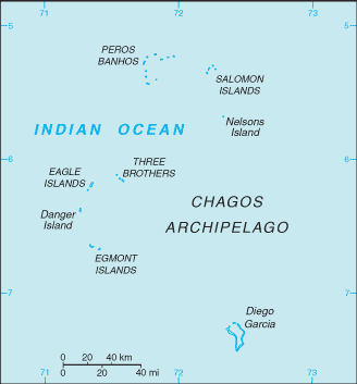
archipelago of 55 islands; Diego Garcia, largest and southernmost island, occupies strategic location in central Indian Ocean; island is site of joint US-UK military facility
Area:
total: 54,400 sq km
land: 60 sq km; Diego Garcia 44 sq km
water: 54,340 sq km
note: includes the entire Chagos Archipelago of 55 islands
Location:
archipelago in the Indian Ocean, south of India, about halfway between Africa and Indonesia
Coastline:
698 km
Area - comparative:
land area is about 0.3 times the size of Washington, DC
Irrigated land:
0 sq km
Environment - current issues:
NA
Maritime claims:
territorial sea: 3 nm
exclusive fishing zone: 200 nm
Natural hazards:
NA
Land use:
arable land: 0%
permanent crops: 0%
other: 100% (2005)
|
|
People
|
Back To Top
|
Population:
no indigenous inhabitants
note: approximately 1,200 former agricultural workers resident in the Chagos Archipelago, often referred to as Chagossians or Ilois, were relocated to Mauritius and the Seychelles in the 1960s and 1970s; in November 2000 they were granted the right of return by a British High Court ruling, though no timetable has been set; in November 2004, approximately 4,000 UK and US military personnel and civilian contractors were living on the island of Diego Garcia
|
|
Government
|
Back To Top
|
Diplomatic representation from the US:
none (overseas territory of the UK)
Diplomatic representation in the US:
none (overseas territory of the UK)
Dependency status:
overseas territory of the UK; administered by a commissioner, resident in the Foreign and Commonwealth Office in London
Legal system:
the laws of the UK, where applicable, apply
Flag description:
white with six blue wavy horizontal stripes; the flag of the UK is in the upper hoist-side quadrant; the striped section bears a palm tree and yellow crown centered on the outer half of the flag
Country name (Goverment):
conventional long form: British Indian Ocean Territory
conventional short form: none
abbreviation: BIOT
Executive branch:
chief of state: Queen ELIZABETH II (since 6 February 1952)
head of government: Commissioner Colin ROBERTS (since July 2008); Administrator Joanne YEADON (since December 2007); note - both reside in the UK and are represented by the officer commanding British Forces on Diego Garcia
cabinet: NA
elections: none; the monarch is hereditary; commissioner and administrator appointed by the monarch
|
|
Economy
|
Back To Top
|
Electricity - consumption:
NA kWh
Currency (code):
US Dollar (USD)
Economy - overview:
All economic activity is concentrated on the largest island of Diego Garcia, where a joint UK-US military facility is located. Construction projects and various services needed to support the military installation are performed by military and contract employees from the UK, Mauritius, the Philippines, and the US. There are no industrial or agricultural activities on the islands. When the native Ilois return, they plan to reestablish sugarcane production and fishing. The territory earns foreign exchange by selling fishing licenses and postage stamps.
Electricity - production:
NA kWh; note - electricity supplied by the US military
|
|
Communications
|
Back To Top
|
Telephones - main lines in use:
NA
Televisions:
NA
Internet country code:
.io
Radio broadcast stations:
AM 1, FM 2, shortwave 0 (1998)
Radios:
NA
Television broadcast stations:
1 (1997)
Telephone system:
general assessment: separate facilities for military and public needs are available
domestic: all commercial telephone services are available, including connection to the Internet
international: country code (Diego Garcia) - 246; international telephone service is carried by satellite (2000)
Internet Service Providers (ISPs):
1 (2000)
Internet hosts:
89 (2008)
|
|
Transportation
|
Back To Top
|
Ports and terminals:
Diego Garcia
Airports - with paved runways:
total: 1
over 3,047 m: 1 (2007)
Roadways:
note: short section of paved road between port and airfield on Diego Garcia
Airports:
1 (2007)
|
|
Military
|
Back To Top
|
Military - note:
defense is the responsibility of the UK; the US lease on Diego Garcia expires in 2016
|
|
Transnational Issues
|
Back To Top
|
Disputes - international:
Mauritius claims the Chagos Archipelago including Diego Garcia; in 2001, the former inhabitants of the Chagos Archipelago, evicted in 1967 and 1973 and now residing chiefly in Mauritius, were granted UK citizenship and the right to repatriation; in May 2007, the UK Court of Appeals upheld the May 2006 High Court of London judgment reversing the UK government's 2004 Orders of Council that banned habitation on the islands; a small group of Chagossians visited Diego Garcia in April 2006; repatriation is complicated by the exclusive US military lease of Diego Garcia that restricts access to the largest viable island in the chain
|
Got something to say on this page? Feel free to
Please limit your comments to discussions about
the subject matter of the content. To report bugs or problems with the ExchangeRate.com web site, please use our contact form here.
Thank You!
|
