Exchange Rate Home >> Country Info >> Kiribati
| Kiribati |
 |
|
|
|
 |
|
Introduction
|
Back To Top
|
Background:
The Gilbert Islands became a British protectorate in 1892 and a colony in 1915; they were captured by the Japanese in the Pacific War in 1941. The islands of Makin and Tarawa were the sites of major US amphibious victories over entrenched Japanese garrisons in 1943. The Gilbert Islands were granted self-rule by the UK in 1971 and complete independence in 1979 under the new name of Kiribati. The US relinquished all claims to the sparsely inhabited Phoenix and Line Island groups in a 1979 treaty of friendship with Kiribati.
|
|
Geography
|
Back To Top
|
Land boundaries:
0 km
Environment - international agreements:
party to: Biodiversity, Climate Change, Climate Change-Kyoto Protocol, Desertification, Hazardous Wastes, Law of the Sea, Marine Dumping, Ozone Layer Protection, Whaling
signed, but not ratified: none of the selected agreements
Climate:
tropical; marine, hot and humid, moderated by trade winds
Map references:
Australia/Oceania
Geographic coordinates:
1 25 N, 173 00 E
Natural resources:
phosphate (production discontinued in 1979)
Elevation extremes:
lowest point: Pacific Ocean 0 m
highest point: unnamed location on Banaba 81 m
Terrain:
mostly low-lying coral atolls surrounded by extensive reefs
Geography - note:
21 of the 33 islands are inhabited; Banaba (Ocean Island) in Kiribati is one of the three great phosphate rock islands in the Pacific Ocean - the others are Makatea in French Polynesia, and Nauru
Area:
total: 811 sq km
land: 811 sq km
water: 0 sq km
note: includes three island groups - Gilbert Islands, Line Islands, Phoenix Islands
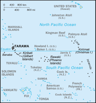
Location:
Oceania, group of 33 coral atolls in the Pacific Ocean, straddling the Equator; the capital Tarawa is about half way between Hawaii and Australia; note - on 1 January 1995, Kiribati proclaimed that all of its territory lies in the same time zone as its Gilbert Islands group (UTC +12) even though the Phoenix Islands and the Line Islands under its jurisdiction lie on the other side of the International Date Line
Coastline:
1,143 km
Area - comparative:
four times the size of Washington, DC
Irrigated land:
NA
Environment - current issues:
heavy pollution in lagoon of south Tarawa atoll due to heavy migration mixed with traditional practices such as lagoon latrines and open-pit dumping; ground water at risk
Maritime claims:
territorial sea: 12 nm
exclusive economic zone: 200 nm
Natural hazards:
typhoons can occur any time, but usually November to March; occasional tornadoes; low level of some of the islands make them sensitive to changes in sea level
Land use:
arable land: 2.74%
permanent crops: 47.95%
other: 49.31% (2005)
|
|
People
|
Back To Top
|
Total fertility rate:
4.08 children born/woman (2008 est.)
Sex ratio:
at birth: 1.05 male(s)/female
under 15 years: 1.03 male(s)/female
15-64 years: 0.98 male(s)/female
65 years and over: 0.74 male(s)/female
total population: 0.99 male(s)/female (2008 est.)
HIV/AIDS - adult prevalence rate:
NA
HIV/AIDS - people living with HIV/AIDS:
NA
Life expectancy at birth:
total population: 62.85 years
male: 59.79 years
female: 66.06 years (2008 est.)
Literacy:
NA
Net migration rate:
NA (2008 est.)
Ethnic groups:
Micronesian 98.8%, other 1.2% (2000 census)
Median age:
total: 20.6 years
male: 20.1 years
female: 21.1 years (2008 est.)
Population:
110,356 (July 2008 est.)
Education expenditures:
17.8% of GDP (2002)
Population growth rate:
2.235% (2008 est.)
Languages:
I-Kiribati, English (official)
Death rate:
7.97 deaths/1,000 population (2008 est.)
Infant mortality rate:
total: 44.69 deaths/1,000 live births
male: 49.61 deaths/1,000 live births
female: 39.53 deaths/1,000 live births (2008 est.)
HIV/AIDS - deaths:
NA
School life expectancy (primary to tertiary education):
total: 12 years
male: 12 years
female: 13 years (2005)
Age structure:
0-14 years: 37.9% (male 21,180/female 20,604)
15-64 years: 58.7% (male 31,993/female 32,797)
65 years and over: 3.4% (male 1,606/female 2,176) (2008 est.)
Birth rate:
30.31 births/1,000 population (2008 est.)
Religions:
Roman Catholic 52%, Protestant (Congregational) 40%, other (includes Seventh-Day Adventist, Muslim, Baha'i, Latter-day Saints, Church of God) 8% (1999)
Nationality:
noun: I-Kiribati (singular and plural)
adjective: I-Kiribati
|
|
Government
|
Back To Top
|
Diplomatic representation from the US:
the US does not have an embassy in Kiribati; the ambassador to Fiji is accredited to Kiribati
National holiday:
Independence Day, 12 July (1979)
Suffrage:
18 years of age; universal
Government type:
republic
Political pressure groups and leaders:
NA
Diplomatic representation in the US:
Kiribati does not have an embassy in the US; there is an honorary consulate in Honolulu
International organization participation:
ACP, ADB, C, FAO, IBRD, ICAO, ICRM, IDA, IFAD, IFC, IFRCS, ILO, IMF, IMO, IOC, ITU, ITUC, OPCW, PIF, Sparteca, SPC, UN, UNCTAD, UNESCO, UPU, WHO, WMO
Legislative branch:
unicameral House of Parliament or Maneaba Ni Maungatabu (46 seats; 44 members elected by popular vote, 1 ex officio member - the attorney general, 1 nominated by the Rabi Council of Leaders (representing Banaba Island); to serve four-year terms)
elections: legislative elections were held in two rounds - the first round on 22 August 2007 and the second round on 30 August 2007 (next to be held in 2011)
election results: percent of vote by party - NA; seats by party - NA, other 2 (includes attorney general)
Legal system:
NA
Flag description:
the upper half is red with a yellow frigate bird flying over a yellow rising sun, and the lower half is blue with three horizontal wavy white stripes to represent the ocean
Independence:
12 July 1979 (from UK)
Country name (Goverment):
conventional long form: Republic of Kiribati
conventional short form: Kiribati
local long form: Republic of Kiribati
local short form: Kiribati
note: pronounced keer-ree-bahss
former: Gilbert Islands
Political parties and leaders:
Boutokaan Te Koaua Party or BTK [Taberannang TIMEON]; Maneaban Te Mauri Party or MTM [Teburoro TITO]; Maurin Kiribati Pati or MKP; National Progressive Party or NPP [Dr. Harry TONG]
note: there is no tradition of formally organized political parties in Kiribati; they more closely resemble factions or interest groups because they have no party headquarters, formal platforms, or party structures
Capital:
name: Tarawa
geographic coordinates: 1 19 N, 172 58 E
time difference: UTC+12 (17 hours ahead of Washington, DC during Standard Time)
Constitution:
12 July 1979
Executive branch:
chief of state: President Anote TONG (since 10 July 2003); Vice President Teima ONORIO; note - the president is both the chief of state and head of government
head of government: President Anote TONG (since 10 July 2003); Vice President Teima ONORIO
cabinet: 12-member cabinet appointed by the president from among the members of the House of Parliament
elections: the House of Parliament chooses the presidential candidates from among its members and then those candidates compete in a general election; president is elected by popular vote for a four-year term (eligible for two more terms); election last held 17 October 2007 (next to be held in 2011); vice president appointed by the president
election results: Anote TONG 63.7%, Nabuti MWEMWENIKARAWA 32.9%
Administrative divisions:
3 units; Gilbert Islands, Line Islands, Phoenix Islands; note - in addition, there are 6 districts (Banaba, Central Gilberts, Line Islands, Northern Gilberts, Southern Gilberts, Tarawa) and 21 island councils - one for each of the inhabited islands (Abaiang, Abemama, Aranuka, Arorae, Banaba, Beru, Butaritari, Kanton, Kiritimati, Kuria, Maiana, Makin, Marakei, Nikunau, Nonouti, Onotoa, Tabiteuea, Tabuaeran, Tamana, Tarawa, Teraina)
Judicial branch:
Court of Appeal; High Court; 26 Magistrates' courts; judges at all levels are appointed by the president
|
|
Economy
|
Back To Top
|
Electricity - consumption:
9.3 million kWh (2006 est.)
Electricity - imports:
0 kWh (2007 est.)
Current account balance:
-$21 million (2007 est.)
Debt - external:
$10 million (1999 est.)
Unemployment rate:
2% official rate; underemployment 70% (1992 est.)
Oil - exports:
0 bbl/day (2005)
GDP - per capita (PPP):
$3,700 (2008 est.)
GDP (purchasing power parity):
$412.5 million (2008 est.)
GDP (official exchange rate):
$71 million (2008 est.)
Exchange rates:
Australian dollars (AUD) per US dollar - 1.2059 (2008 est.), 1.2137 (2007), 1.3285 (2006), 1.3095 (2005), 1.3598 (2004)
GDP - real growth rate:
3.7% (2008 est.)
Labor force:
7,870 economically active, not including subsistence farmers (2001 est.)
Inflation rate (consumer prices):
0.2% (2007 est.)
GDP - composition by sector:
agriculture: 8.9%
industry: 24.2%
services: 66.8% (2004)
Oil - imports:
259.1 bbl/day (2005)
Exports:
$17 million f.o.b. (2004 est.)
Natural gas - consumption:
0 cu m (2007 est.)
Currency (code):
Australian dollar (AUD)
Economy - overview:
A remote country of 33 scattered coral atolls, Kiribati has few natural resources and is one of the least developed Pacific Islands. Commercially viable phosphate deposits were exhausted at the time of independence from the UK in 1979. Copra and fish now represent the bulk of production and exports. The economy has fluctuated widely in recent years. Economic development is constrained by a shortage of skilled workers, weak infrastructure, and remoteness from international markets. Tourism provides more than one-fifth of GDP. Private sector initiatives and a financial sector are in the early stages of development. Foreign financial aid from the EU, UK, US, Japan, Australia, New Zealand, Candad, UN agencies, and Taiwan accounts for 20-25% of GDP. Remittances from seamen on merchant ships abroad account for more than $5 million each year. Kiribati receives around $15 million annually for the government budget from an Australian trust fund.
Natural gas - exports:
0 cu m (2007 est.)
Imports - commodities:
foodstuffs, machinery and equipment, miscellaneous manufactured goods, fuel
Industries:
fishing, handicrafts
Electricity - exports:
0 kWh (2007 est.)
Population below poverty line:
NA%
Electricity - production:
10 million kWh (2006 est.)
Imports:
$62 million c.i.f. (2004 est.)
Oil - proved reserves:
0 bbl (1 January 2006 est.)
Labor force - by occupation:
agriculture: 2.7%
industry: 32%
services: 65.3% (2000)
Natural gas - proved reserves:
0 cu m (1 January 2006 est.)
Oil - consumption:
232.4 bbl/day (2006 est.)
Market value of publicly traded shares:
$NA
Currency code:
AUD
Household income or consumption by percentage share:
lowest 10%: NA%
highest 10%: NA%
Exports - commodities:
copra 62%, coconuts, seaweed, fish
Economic aid - recipient:
$27.84 million largely from UK and Japan (2005)
Electricity - production by source:
fossil fuel: 100%
hydro: 0%
nuclear: 0%
other: 0% (2001)
Natural gas - imports:
0 cu m (2007 est.)
Natural gas - production:
0 cu m (2007 est.)
Budget:
revenues: $55.52 million
expenditures: $59.71 million (FY05)
Fiscal year:
NA
Oil - production:
0 bbl/day (2007 est.)
|
|
Communications
|
Back To Top
|
Internet users:
2,000 (2007)
Telephones - main lines in use:
4,500 (2002)
Televisions:
1,000 (1997)
Internet country code:
.ki
Radio broadcast stations:
AM 1, FM 2, shortwave 1 (may be inactive) (2002)
Radios:
17,000 (1997)
Telephones - mobile cellular:
700 (2005)
Television broadcast stations:
1 (possibly inactive) (2002)
Telephone system:
general assessment: generally good quality national and international service
domestic: wire line service available on Tarawa and Kiritimati (Christmas Island); connections to outer islands by HF/VHF radiotelephone; wireless service available in Tarawa since 1999
international: country code - 686; Kiribati is being linked to the Pacific Ocean Cooperative Telecommunications Network, which should improve telephone service; satellite earth station - 1 Intelsat (Pacific Ocean)
Internet Service Providers (ISPs):
1 (2000)
Internet hosts:
9 (2008)
|
|
Transportation
|
Back To Top
|
Waterways:
5 km (small network of canals in Line Islands) (2007)
Ports and terminals:
Betio
Merchant marine:
total: 43
by type: bulk carrier 2, cargo 18, chemical tanker 3, petroleum tanker 6, refrigerated cargo 14
foreign-owned: 31 (China 15, Hong Kong 4, South Korea 2, Singapore 4, Taiwan 5, Turkey 1) (2008)
Airports - with paved runways:
total: 4
1,524 to 2,437 m: 4 (2007)
Roadways:
total: 670 km (2000)
Airports - with unpaved runways:
total: 15
914 to 1,523 m: 11
under 914 m: 4 (2007)
Airports:
19 (2007)
|
|
Military
|
Back To Top
|
Manpower available for military service:
males age 16-49: 26,377 (2008 est.)
Military - note:
Kiribati does not have military forces; defense assistance is provided by Australia and NZ
Manpower fit for military service:
males age 16-49: 17,577 (2008 est.)
Military branches:
no regular military forces (constitutionally prohibited); Police Force (2008)
Manpower reaching militarily significant age annually:
male: 1,247
female: 1,226 (2008 est.)
Military expenditures:
NA
|
|
Transnational Issues
|
Back To Top
|
Disputes - international:
none
|
Got something to say on this page? Feel free to
Please limit your comments to discussions about
the subject matter of the content. To report bugs or problems with the ExchangeRate.com web site, please use our contact form here.
Thank You!
|
