Exchange Rate Home >> Country Info >> Christmas Island
| Christmas Island |
 |
|
|
|
 |
|
Introduction
|
Back To Top
|
Background:
Named in 1643 for the day of its discovery, the island was annexed and settlement began by the UK in 1888. Phosphate mining began in the 1890s. The UK transferred sovereignty to Australia in 1958. Almost two-thirds of the island has been declared a national park.
|
|
Geography
|
Back To Top
|
Land boundaries:
0 km
Climate:
tropical with a wet season (December to April) and dry season; heat and humidity moderated by trade winds
Map references:
Southeast Asia
Geographic coordinates:
10 30 S, 105 40 E
Natural resources:
phosphate, beaches
Elevation extremes:
lowest point: Indian Ocean 0 m
highest point: Murray Hill 361 m
Terrain:
steep cliffs along coast rise abruptly to central plateau
Geography - note:
located along major sea lanes of Indian Ocean
Area:
total: 135 sq km
land: 135 sq km
water: 0 sq km
Location:
Southeastern Asia, island in the Indian Ocean, south of Indonesia
Coastline:
138.9 km
Area - comparative:
about three-quarters the size of Washington, DC
Irrigated land:
NA
Environment - current issues:
loss of rainforest; impact of phosphate mining
Maritime claims:
territorial sea: 12 nm
contiguous zone: 12 nm
exclusive fishing zone: 200 nm
Natural hazards:
the narrow fringing reef surrounding the island can be a maritime hazard
Land use:
arable land: 0%
permanent crops: 0%
other: 100% (mainly tropical rainforest; 63% of the island is a national park) (2005)
|
|
People
|
Back To Top
|
Total fertility rate:
NA (2008 est.)
Sex ratio:
NA
HIV/AIDS - adult prevalence rate:
NA
HIV/AIDS - people living with HIV/AIDS:
NA
Life expectancy at birth:
total population: NA
male: NA
female: NA (2008 est.)
Literacy:
NA
Net migration rate:
NA (2008 est.)
Ethnic groups:
Chinese 70%, European 20%, Malay 10%
note: no indigenous population (2001)
Population:
1,402 (July 2007 est.)
Population growth rate:
0% (2008 est.)
Languages:
English (official), Chinese, Malay
Death rate:
NA (2008 est.)
Infant mortality rate:
total: NA
male: NA
female: NA (2008 est.)
HIV/AIDS - deaths:
NA
Age structure:
0-14 years: NA
15-64 years: NA
65 years and over: NA
Birth rate:
NA (2008 est.)
Religions:
Buddhist 36%, Muslim 25%, Christian 18%, other 21% (1997)
Nationality:
noun: Christmas Islander(s)
adjective: Christmas Island
|
|
Government
|
Back To Top
|
Diplomatic representation from the US:
none (territory of Australia)
National holiday:
Australia Day, 26 January (1788)
Government type:
NA
Political pressure groups and leaders:
none
Diplomatic representation in the US:
none (territory of Australia)
Dependency status:
non-self governing territory of Australia; administered from Canberra by the Australian Attorney-General's Department
International organization participation:
none
Legislative branch:
unicameral Christmas Island Shire Council (9 seats; members elected by popular vote to serve four-year terms)
elections: held every two years with half the members standing for election; last held 20 October 2007 (next to be held in 2009)
election results: percent of vote - NA; seats - independents 9
Legal system:
under the authority of the governor general of Australia and Australian law
Flag description:
territorial flag; divided diagonally from upper hoist to lower fly; the upper triangle is green with a yellow image of the Golden Bosun Bird superimposed, while the lower triangle is blue with the Southern Cross constellation, representing Australia, superimposed; a centered yellow disk displays a green map of the island
note: the flag of Australia is used for official purposes
Independence:
none (territory of Australia)
Country name (Goverment):
conventional long form: Territory of Christmas Island
conventional short form: Christmas Island
Political parties and leaders:
none
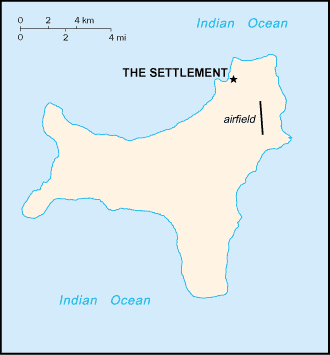
Capital:
name: The Settlement
geographic coordinates: 10 25 S, 105 43 E
time difference: UTC+7 (12 hours ahead of Washington, DC during Standard Time)
Constitution:
Christmas Island Act of 1958-59 (1 October 1958) as amended by the Territories Law Reform Act of 1992
Executive branch:
chief of state: Queen ELIZABETH II (since 6 February 1952), represented by the Australian governor general
head of government: Administrator Neil LUCAS (since 30 January 2006)
elections: the monarch is hereditary; administrator appointed by the governor general of Australia and represents the monarch and Australia
Administrative divisions:
none (territory of Australia)
Judicial branch:
Supreme Court; District Court; Magistrate's Court
|
|
Economy
|
Back To Top
|
GDP (purchasing power parity):
$NA
Exchange rates:
Australian dollars (AUD) per US dollar - 1.2059 (2008 est.), 1.2137 (2007), 1.3285 (2006), 1.3095 (2005), 1.3598 (2004)
Labor force:
NA
Exports:
$NA
Currency (code):
Australian dollar (AUD)
Economy - overview:
Phosphate mining had been the only significant economic activity, but in December 1987 the Australian Government closed the mine. In 1991, the mine was reopened. With the support of the government, a $34 million casino opened in 1993, but closed in 1998. The Australian Government in 2001 agreed to support the creation of a commercial space-launching site on the island, expected to begin operations in the near future.
Imports - commodities:
consumer goods
Industries:
tourism, phosphate extraction (near depletion)
Imports:
$NA
Currency code:
AUD
Exports - commodities:
phosphate
Economic aid - recipient:
$NA
Electricity - production by source:
fossil fuel: NA
hydro: NA
nuclear: NA
other: NA
Budget:
revenues: $NA
expenditures: $NA
Fiscal year:
1 July - 30 June
|
|
Communications
|
Back To Top
|
Internet users:
464 (2001)
Telephones - main lines in use:
NA
Televisions:
600 (1997)
Internet country code:
.cx
Radio broadcast stations:
AM 1, FM 2, shortwave 0 (2006)
Radios:
1,000 (1997)
Television broadcast stations:
0 (TV broadcasts received via satellite from mainland Australia) (2006)
Telephone system:
general assessment: service provided by the Australian network
domestic: GSM mobile telephone service replaced older analog system in February 2005
international: country code - 61-8; satellite earth station - 1 (Intelsat provides telephone and telex service) (2005)
Internet Service Providers (ISPs):
2 (2000)
Internet hosts:
1,821 (2008)
|
|
Transportation
|
Back To Top
|
Ports and terminals:
Flying Fish Cove
Airports - with paved runways:
total: 1
1,524 to 2,437 m: 1 (2007)
Roadways:
total: 140 km
paved: 30 km
unpaved: 110 km (2007)
Airports:
1 (2007)
|
|
Military
|
Back To Top
|
Military - note:
defense is the responsibility of Australia
|
|
Transnational Issues
|
Back To Top
|
Disputes - international:
none
|
Got something to say on this page? Feel free to
Please limit your comments to discussions about
the subject matter of the content. To report bugs or problems with the ExchangeRate.com web site, please use our contact form here.
Thank You!
|
